Well, at least we did get some snow here last night. After receiving over a half inch of rain and ice pellets, about a half inch of snow fell just after midnight. Not the 2 to 4 I was looking for, but snow never the less!
As for the upcoming week, it looks mostly fair and colder. Look for a few snow squalls toward morning Tuesday, then clearing and colder as a massive high pressure system moves into the area Thursday. Temperatures should be below the 30 year averages by the end of the week. Stay warm!
Monday, December 31, 2007
Saturday, December 29, 2007
What's that bright ball in the sky??
Finally, a bit of sun..if only short lived. I'm looking for the good weather to hold through part of Sunday. Sunday evening into Monday could bring our first chance for some real snow this season. The potential exists for 2 to 4 inches. As usual, the exact track of the storm and the temperatures at the time will determine the outcome.
Monday, December 24, 2007

Saturday, December 22, 2007
White Christmas??
No, I don't think so. The upcoming weeks looks a bit unsettled. A series of fronts and pressure areas will be marching across the area next week bringing everything but snow. Sunday looks cool and damp. Monday should start the clearing trend. As for the rest of the week, how many ways can you say partly cloudy, chance of showers?
Monday, December 17, 2007
Back on the air after the storm.
 Finally, we have all our services back. Schaefferstown lost power, cable, and phone service as a result of Sunday's ice storm. Luckily, the direct impact to our immediate area was relatively low. A few smaller branches came down along with 2 antennas here at N3HCP, Radio Free Schaefferstown. Several hours with surface temperatures above freezing at the start of the storm helped hold ice accumulation down to about 1/4 inch. Other parts of Lebanon county weren't as luckily.
Power was out for 27 hours from early Sunday until Monday morning...a relatively short time, all things considered. We were able to keep ourselves comfortable and keep the satellite TV going with the use of the back-up generator.
Friday, December 14, 2007
Here we go again...
Yet another "too close to call" storm. The timing looks pretty well set. The Storm should arrive early Saturday evening and wind up sometime Sunday afternoon. Areas north and west will get mostly snow, south and east, less snow, more ice and just rain. As so often seems to happen, southern Lebanon County is right on the edge. With the sub tropical air bring carried north by the remains of Tropical Storm Olga, my thinking is Schaefferstown will be more on the rain/freezing rain side of the line. Time will tell...
Thursday, December 13, 2007
Icy morning

Well, we did get some icing this morning. The temperature started out just about 32 at 07:00 and then dropped to 30 for most of the morning now (11:45) it's starting to go up again. The rain is still freezing on cold surfaces. With the freezing line right over our heads we will probably hang right around 32 for several hours, meaning the wintry mix will continue until it tapers off this evening. This is one of those situations where one side of town has ice and sleet, while the other side has rain. Go figure!
Wednesday, December 12, 2007
Bread and milk warning!!
I have been reminded by my brother that a bread and milk warning is now called for! People should mob grocery stores as soon as possible and stock up!!!
Here comes winter!

We may be on the verge of seeing some real winter weather over the next few days. The warm air will be making a retreat this afternoon and evening. Watch for clearing skies tonight. The clearer the skies are overnight the colder the surface will become and the better the chance any rain we get will freeze on contact. The potential exists for a half an inch of ice across the southern part of the state. Now the disclaimer...as so often happens here, we will be near the freezing line so it can still go either way. Time will tell, but prepare for the worst.
Tuesday, December 11, 2007
Boring!!

The "flatness" continues. There has been very little rain in the last 36 hours, yet the humidity is do high that nothing dries off. It looks like this trend will continue through at least Thursday.
Sunday, December 9, 2007
A "flat" day...
Well, we missed the ice this morning. There was a little drizzle but the surface temp was high enough to prevent icing. The day now is just flat. No rain, no snow, no sun no texture to the sky, everything is just flat! If there ever was a day to spend in front of the TV with a bag of cheese puffs, this is it!! Enjoy!!!
Friday, December 7, 2007
The Weekend and beyond...
Looks like we are in for a few days on unsettled weather. Today and Saturday morning could see a few showers, rain or snow, your choice, followed by a bit of sun Saturday afternoon. But it looks to be downhill from there. Sunday could start out with freezing rain in the morning, warming up a bit afternoon. Next week look for a frontal boundary to set up from west to east across the area. With that set up we could see precipitation at almost any time out to maybe as late at Thursday. The up side is it will probably be warm enough to keep the precip all, or mostly, liquid. Stay tuned....
Wednesday, December 5, 2007

Schaefferstown's first measurable snow is underway. This Alberta Clipper is producing a couple inches and is making the roads a bit slick. As always with the frist snow of the season, drivers seem to have forgotten how to drive in this stuff. Let's be careful out there!!I just took a close look at the picture...I guess your in the country when a picture taken out the kitchen window shows two silos!!
Tuesday, December 4, 2007
Wind!
We've had some interesting wind in the last 24 hours. The highest gust reported here was 36 at 2121h on Monday. Because the weather station only records wind every 2 seconds and then averages the speed over that time, we tend to miss the actual high gusts, so the actual high gust must have been over 40mph. We were also treated to several lake effect snow squalls. When you consider that the fetch of the wind bringing snow from Lake Erie is around 250 miles, that's really quite amazing!
Sunday, December 2, 2007
After the "storm"
Well, that was a lot of nothing. I suppose I should go back and delete my forecast, but I won’t. We didn’t even get enough prescription to show up in the rain bucket!
Sunday morning...
It looks like most of the storm is going to our north. We have a little sleet and freezing rain this morning, and that will continue for a few hours. Most of the rain will come this evening with a half an inch likely. Watch out for the winds on Monday in the wake of the storm.
Saturday, December 1, 2007
Storm update
This morning's precipitation model is taking the bulk of the precip north of us. Given that, Monday morning is looking better then it did yesterday. Nevertheless, the lower Susquehanna Valley is looking for something around .75 inches of liquid between Sunday 7:00 AM and the same time Monday, with most of that during the day Sunday. Tomorrow morning could be a mess around here.
Friday, November 30, 2007
Weekend storm

I’ve been looking at the forecast runs this morning trying to get a handle on the weekend storm. At this point Saturday night into Sunday afternoon looks like a mixed bag. The air at the surface doesn’t look cold enough to support much snow and freezing rain. Ice pellets, on the other hand, could be a problem. I’m actually more interested in Sunday evening into Monday morning. Some of the models seem to indicate a snow event later Sunday. We’ll see…
Thursday, November 29, 2007
And now a word from our sponsor...
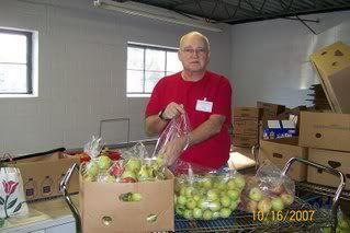
OK, it's not the sponsor, but here's the commercial anyway. I'm talking about Lebanon County Christian Ministries, now and hereafter referred to as LCCM. Among other services, LCCM operates the local food ban, where both my wife and I volunteer. Check out the web site at http://www.lccm.us/ .
The food bank is always in need of donations...nonperishable food, personal care items, paper products, anything you buy every week at the grocery store. We will gladly accept contributions from individuals as well as churches, businesses, anyone who wants to give.
Readers in other areas, don't despair. Most places have some sort of food bank to which you can donate. Just pick up a few extra items the next time you go grocery shopping and drop them off. It will be appreciated!
Broken leg update
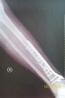
The leg continues to heal. The only restriction is stay off the roof , imposed my Mrs. N3HCP, or as we say in the ham radio world, the XYL (eX Young Lady)! I also need to use the bone stimulator 10 hours a day. Hopefully, that will be over after the next doctor appointment in early January. It's been an interesting experience, but one I don't care to repeat any time soon.
The blog is back!
Yes...it's true! The blog is back! Yes, I know blogs are self serving, egocentric, and of little socially redeeming value. But, let's face it...that's a good description on me!
OK...on to the important stuff. Now that we have a DSL connection, I have been able to bring the weather station back on line. As some of you might remember, a few years ago I poster weather data on my web page, until the computer that was running it went up in smoke...literally!
The new setup is a bit more sophisticated. It will post the local weather data to the web page, that APRS radio network, and the the Weather Underground web site. The local web page is updated once a minute.
Now what you've all been waiting for (insert drum roll and dramatic music here)...the URL to the new and improved Schaefferstown Weather Web Site......
http://www.n3hcp.com/
This is mostly a page of links to other pages. The local stuff is at the top, but don't forget to scroll down. There's some good stuff toward the bottom too. ENJOY!!
OK...on to the important stuff. Now that we have a DSL connection, I have been able to bring the weather station back on line. As some of you might remember, a few years ago I poster weather data on my web page, until the computer that was running it went up in smoke...literally!
The new setup is a bit more sophisticated. It will post the local weather data to the web page, that APRS radio network, and the the Weather Underground web site. The local web page is updated once a minute.
Now what you've all been waiting for (insert drum roll and dramatic music here)...the URL to the new and improved Schaefferstown Weather Web Site...
http://www.n3hcp.com/
This is mostly a page of links to other pages. The local stuff is at the top, but don't forget to scroll down. There's some good stuff toward the bottom too. ENJOY!!
Subscribe to:
Posts (Atom)